South Uist Projects and Environmental Research (Cardiff)
The Western Isles of Scotland has an archaeological record that is exceptional.
It has some of the best preserved examples of chambered tombs, brochs, castles and early churches in Britain and an unparalleled landscape of abandoned post medieval settlement. The machair landscapes of the coastline have sites with stratigraphic sequences that span millennia of occupation and which contain fragile remains that provide evocative pictures of past lives. The landscapes of machair and peat also preserve detailed information on early economies and environments that are of considerable importance to our understanding of the past landscapes of the British Isles.
Cardiff University has a long history of interest in the Western Isles that began with Professor Richard Atkinson’s excavations at Sollas on North Uist in 1957. In recent years they have had a long running research project on the island of South Uist that has been particularly important in exploring the human occupation of the island from the Neolithic through to the end of the medieval period.
This has transformed our understanding of the nature of social relations in the Iron Age, provided data on the agricultural economy of both prehistory and the medieval period and given a valuable insight into the colonisation of the islands by the Vikings and the nature of later Norse settlements. Much of this work has been done in close cooperation with the Department of Prehistory at Sheffield University and has been generously supported by funding from Historic Scotland.
South Uist geography
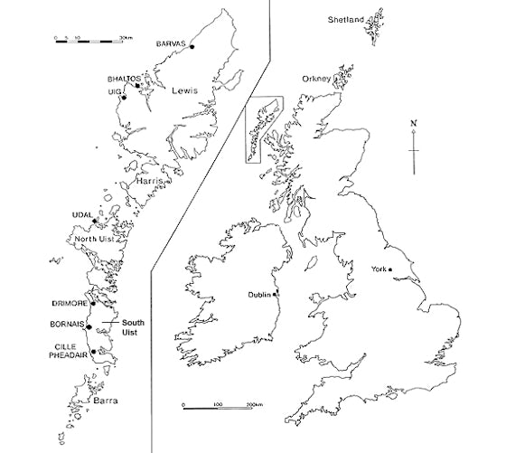
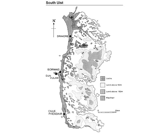
South Uist is a small island, approximately 36,467 ha, in the southern half of the Outer Hebrides or Western Isles. To the north the island is currently joined to the neighbouring island of Benbecula by an artificial causeway; however, access between the islands at low tide is possible and for much of prehistory South Uist, Benbecula and North Uist would have formed a single landmass.
The channel between South Uist and Barra is more substantial and would have separated the islands from relatively early in the postglacial period. The current island is rectangular, roughly 35 km long and up to 13.6 km wide with its long axis oriented north-south. The landscape can be divided into three strips of very distinctive environments running from north to south.
- The east half of the island is an inhospitable region dominated by mountains, the highest of which is Beinn Mhor (608 metres), interspersed with large expanses of peat moorland. The coastline varies from cliffs to small sheltered bays, but the most important features are the three deep sea lochs, Loch Baghasdail, Loch Aineort and Loch Sgiopoirt, which penetrate through the mountains to the low-lying land which lies at the centre of the island.
- Moving westward the land gradually descends, first through an area of moorland then to a region distinguished by extensive freshwater lochs separated by rocky outcrops. The central and eastern part of the islands are collectively referred to as the blacklands.
- The west coast is characterised by a shell sand deposit known as the machair. On South Uist this extends as a continuous plain, up to 2 km wide, from the south to the north coast, and runs along the west coast of Benbecula and North Uist. Projecting from this coastline are two distinctive promontories; in the middle of the island is Rubha Ardvule, a low promontory, and at the south end is Orosay, a steep-sided tidal islet.
Today, settlement is concentrated on the rocky outcrops between the freshwater lochs on the blacklands adjacent to the machair plain of the west coast. The islanders exploit the land in their immediate vicinity, cultivate the machair plain and use the eastern uplands as a summer grazing resource. The sea lochs of the east coast provide sheltered anchorages and small settlements oriented on fishing, or fish farming, are found scattered around their shores. Access to the Scottish mainland is also channelled through these sea lochs and has resulted in the development of a port at Loch Baghasdail.
Images
- Figure 1: Location of South Uist in the Outer Hebrides.
- Figure 2: Detailed map of South Uist.
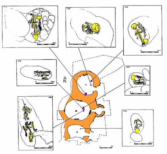
- Figure 3: Diagram of the excavation at Cladh Hallan.
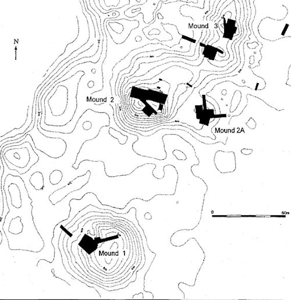
- Figure 4: Location of settlement mounds on the Bornais machair.
History of Cardiff research in the Uists
Cardiff’s interest in the Outer Hebrides is long term. In 1957 the wheelhouse at Machair Leathann, Sollas, North Uist was excavated by Richard Atkinson, then Professor of archaeology at Cardiff University, and these excavations were written up by a post graduate student of the department, Ewan Campbell.
Alan Lane was involved in the excavations at the Udal in North Uist from 1970-72 and undertook the analysis of the Late Iron Age and Norse ceramic assemblage from this site for his doctorate at University College, London.
Niall Sharples first became involved with the islands in 1977 when, together with Alan Lane, he took part in a coastal erosion survey of Lewis and Harris. Niall went on to take part in several minor excavations on the islands in the early 1980s that culminated in the excavation of an Early Bronze Age settlement at Dalmore on Lewis. Jacqui Mulville’s first Hebridean experience was in 1988, when she took part in excavations on Islay with Steve Mithen.
The current programme of work
The current programme of work evolved from an initiative by Sheffield University in the late 1980s. The SEARCH project was instigated by Richard Hodges and Dave Gilbertson and the first field season, in 1988, involved survey and small scale excavation on Barra and South Uist.
Jacqui Mulville became part of the SEARCH project in 1989 (with Helen Smith), as a PhD student at Sheffield. Niall Sharples (along with Mike Parker Pearson) joined the project in 1991 and when he moved to the University of Cardiff in 1995 the project became an important training excavation for the department of archaeology.
After leaving Sheffield Jacqui Mulville, continued to excavate on South Uist and report on the faunal remains, eventually moving to Cardiff in 2002 and developing a centre for bioarchaeology and related scientific analysis. The project has operated an open door policy which has encouraged the participation of many individuals and universities; including Bournemouth, Glasgow, London, Oxford, Southampton and Winchester.
The machair
The principal focus for the South Uist team became the excavation of sites on the machair. This landscape seemed to be an ideal environment for the preservation of exceptional archaeology. It had the potential to provide refined chronological sequences, substantial assemblages of material culture, well preserved architecture and a full suite of economic information. The research programme would provide a case study of broad relevance to the discipline of archaeology.
Over the last two decades the South Uist team has excavated a large number of sites and surveyed extensive areas of the island. The initial focus for excavation was the broch and settlement at Dun Vulan, a project jointly directed by Niall Sharples and Mike Parker Pearson. After 1995 the project worked on a number of sites and surveys in parallel.
The principal focus for the Cardiff University team has been the excavation of the Late Iron Age and Norse settlement at Bornais. The principal Sheffield University excavations were undertaken on the Norse settlement at Cille Pheadair, the Late Bronze Age and Early Iron Age settlements at Cladh Hallan (co-directed by Jacqui Mulville) and the post-Medieval township of Airigh Mhuillin, Milton.
A variety of field surveys and small-scale excavations were also undertaken as part of the overall landscape project.
The surveys include:
- The landscape around Locheynort in the centre of the island.
- The blacklands of the township of Cill Donnain.
- The machair plain.
- The landscape setting of the chambered tombs.
Small scale excavations include:
- The potential Neolithic settlement at Loch a’Choire.
- The chambered tomb and enclosure at Leaval.
- The Beaker and Iron Age settlements at Sligeanach.
- The dun in Upper Loch Bornais.
- The Pictish burial at Cille Pheadair.
- The Late Norse and Medieval church at Cill Donnain.
- The Late Medieval settlement at Beinn Na Mhic Aongheis, Bornais.
- Ormiclate Castle.
- The Post Medieval settlements of Frobost and Kirkidale, South Locheynort.
- Bothies on Rubha Ardvule.
These excavations have provided an exceptionally broad coverage of the island’s archaeology that spans the period from the Neolithic to the nineteenth century.
Early prehistoric settlement
The early prehistoric settlement has not been a major focus of research for the project. It is hoped that this area of research will be developed but financing new research has proved difficult. Nevertheless several important pieces of work have been undertaken and a picture of the nature of settlement is beginning to emerge.
Neolithic settlement has proved difficult to locate on South Uist, in contrast to the islands of Barra and North Uist. The known settlements of Late Neolithic date have been located on the blacklands and not on the machair and this might indicate that these shell sand deposits were still an unstable landform in the Neolithic period.
In 2000 a survey of inland lochs was undertaken by Cole Henley as part of his doctoral research at Cardiff. This resulted in the discovery of a scatter of flint and pottery of Neolithic date from Loch a’Choire on the south coast of South Uist. A limited series of test pits indicated only superficial evidence for settlement activity but further research needs to be undertaken.
In 1995 a large storm exposed another Neolithic settlement site at An Doirlinn on south west corner of the island. Stone walls indicative of structures were present and occupation deposits contained large quantities of flint, and isolated pieces of worked quartz, pumice, stone tools and pottery. A large carinated rim sherd, with characteristic diagonal line decoration, indicates a Neolithic date for the occupation.
Chambered tombs
Our understanding of the broader occupation of the island in the Neolithic is dependant on the location of the chambered tombs. Detailed analysis has revealed that most of the tombs were constructed on high ground overlooking the west coast of the island. However, they are not positioned to maximise the views of the coastal plain; instead they are located on the edges of valleys that lead into the interior or to the east coast of the island.
The most likely explanation for this pattern is that the tombs overlook valleys that were important for the seasonal movement of animals, from the settlements on the west coast through to moorland and upland grazing in the centre of the island.
Several Beaker settlements indicate the colonisation of the machair plain around the period 2400-2200 cal BC and provide some of the best evidence for Beaker settlement in Europe. Erosion of the site of Cill Donnain I revealed a substantial structure similar to those excavated at Northton and Dalmore.
Test excavation of the site at Sligeanach identified an extensive settlement area with traces of ard cultivation and structural remains of indeterminate significance. The excavation of the later Bronze Age settlement at Cladh Hallan also discovered an underlying Beaker settlement associated with cultivation traces.
Later prehistoric settlement: The beginnings
The later prehistoric sequence on the machair begins in the Late Bronze Age and Early Iron Age and a small number of substantial settlements have been identified scattered along the length of the island, including one at Sligeanach test pitted by the Cardiff team.
The most thoroughly explored of these locations is the site at Cladh Hallan, which has been the subject of intensive excavation by Mike Parker Pearson and Jacqui Mulville. The main excavation area exposed a row of four circular houses surrounded by a large area of midden and ancillary activity areas. The three excavated houses face east or south east and appear to be constructed at the same time.
The central house has a lengthy occupation and seven separate floor levels have been identified all of which contain important artefactual evidence for the use of the building. In contrast the other houses have only two and three floors and appear to have gone out of use well before the abandonment of the central house.
Foundation burials
All the houses had foundation burials of human skeletons beneath their primary floors and several of these burials have been identified as ‘mummies’. The final phase of occupation on the settlement included the construction of two double-celled houses. One of these was built on the edge of the main settlement and the other was in a separate location to the north. Neither house was very well preserved.
Cladh Hallan has produced a substantial assemblage of undecorated ceramics and a massive assemblage of animal bones which will provide a detailed picture of the economy of the site. More surprisingly several bronze objects have also been recovered including chisels, fragments of bracelets and a gold-plated hair ring.
There is also evidence for bronze casting and metalworking that includes bronze spills and moulds for disc headed pins and Ewart Park swords. These finds demonstrate that the occupants were linked to networks that cover mainland Britain, Ireland and the continent and that the islands were very well connected in the Bronze Age.
Later prehistoric settlement: The developed period
The distribution of Middle Iron Age settlements, dating to the period around 200BC-AD400 is well defined but by no means complete. The pattern in the densely occupied areas suggests a fairly even spacing of settlements every 2-3 km along the machair plain. It seems likely that this spacing represents the division of the island into territories that are oriented east west across the natural landscape zones and indicate an equitable division of the different landscapes and the different resources of the island.
Several Middle Iron Age settlements have been excavated on the machair plain of South Uist (Kilphedir; A’Cheardach Mhor; A’Cheardach Bheag; Cill Donnain). These settlements are characterised by the construction of substantial semi-subterranean roundhouses that are internally divided by stone piers, causing them to be named wheelhouses.
Cardiff have excavated a badly robbed wheelhouse at Bornais but despite the lack of any upstanding walls the site provided important evidence for the roofing of these structures as the house had been burnt during its life and the reoccupation had preserved the collapsed roof timbers under the new floor.
Brochs
Contemporary with the wheelhouses are brochs, free standing stone buildings with impressively thick stone walls that indicate a wall height that can be up to 11 metres high. Around 12 of these structures have been identified on South Uist. The size and architectural complexity of these structures indicates their construction by small scale communities but they were also clearly houses occupied by a single family.
A considerable degree of prestige must have been acquired by the occupation of these structures and it seems inescapable that the occupants played an important role in the communities to which they were attached.
All but one of the brochs was built on an artificial island in the inland lochs of the blacklands between the machair and the hills. They are liminal in every sense of the word, set apart from the densely occupied cultivated fields of the machair. The exception, Dun Vulan, was built on a rocky promontory projecting into the Atlantic. The position of the brochs seems to symbolise the ambiguous position of leadership in these communities.
During the Late Iron Age or early medieval period it is difficult to document the continuation of these settlement patterns by field survey alone. The ceramics recovered from field survey are not sufficiently distinctive to securely identify a Late Iron Age settlement as these are characterised by a decline in decoration.
However, excavation of the broch at Dun Vulan indicates a continuation of activity on the site up to the seventh century AD and excavations at Bornais suggests that, after the abandonment of the wheelhouse in the fifth century AD, settlement shifted to an adjacent mound, less than 100 metres away.
Historic settlement: Vikings and Medieval activity
Norse settlements are relatively easy to locate on the machair due to the presence of distinctive ceramic platters. Approximately 23 settlements have been identified and these settlements are fairly evenly distributed along the machair plain and occur close to, or on top of, Iron Age settlements. These relationships are demonstrated by the two excavated settlements at Bornais and Cille Pheadair.
Bornais is a substantial settlement that lies in the centre of the island on the machair plain. The earliest excavated structure dates to the end of the Middle Iron Age and the occupation continues through the Pictish and Viking periods to end at the beginning of the fifteenth century. In contrast the Norse settlement at Cille Pheadair was established on an area of machair that was previously unoccupied though close to an existing Iron Age settlement mound.
There are significant differences between the two excavated Viking/Norse settlements. Bornais is much larger, comprising at least five separate mounds equivalent to the Cille Pheadair settlement. One of the mounds at Bornais, mound 2, is much larger and excavation has revealed a sequence of houses of considerable size and sophistication.
The best-preserved house is a substantial bow-shaped stone-walled hall almost 20 metres long and 6m wide. It was built on top of a house estimated to be 23.1 m long and was succeeded by a building 12 m long by 5.4m wide. These buildings are much larger than the Cille Pheadair houses and the houses built on the subsidiary mounds at Bornais.
Artefacts
Both settlements have produced large quantities of artefacts, which suggest they were occupied by individuals with widespread connections in the Scandinavian areas of the North Atlantic. These include copper alloy pins imported from Ireland, gold decorative fittings, silver coins from England and Norway, steatite from Shetland, ceramics from southern England, antler combs from Norway and ivory, possibly from Greenland.
Bornais has produced antler decorated with a classic Ringerike style animal that was probably imported from Scandinavia. Evidence for Christianity at Cille Pheadair include two bone crosses, and at Bornais two small lead crosses and two fragments of green porphyry possibly from Rome have been recovered.
Historic settlement: The post medieval period
Sometime around the fourteenth century there was a significant change in the settlement landscape of South Uist. The machair plain was abandoned and the inhabitants moved to the adjacent areas of the blacklands. The excavation evidence indicates that both Bornais and Cille Pheadair were abandoned sometime in the fifteenth century AD and field survey of the machair seldom recovers later ceramics.
Unfortunately field survey and excavation on the blacklands has only recovered insubstantial traces of pre-eighteenth century domestic settlements as the turf built buildings belonging to this period leave very little surviving traces above ground. The replacement settlement for Bornais was probably located at the ‘Hill of the Son of Angus’, and trial trenching by Mike Parker Pearson suggests the buildings are similar to the final phase buildings of the late Norse period.
In contrast our understanding of the settlement pattern in the late-eighteenth and nineteenth century is good as the construction of buildings with stone walls resulted in the survival of substantial archaeological monuments. A detailed study is being undertaken by Jim Symonds of the settlement at Airigh Mhuillin, Milton and excavations have also been undertaken at Frobost and Kirkidale.
Houses found on these settlements include structures comparable in size to the turf buildings of the later Norse settlements but also more substantial longhouses with internal byres. Associated with these domestic dwellings are ancillary structures some of which contain corn-drying kilns.
Nineteenth century
The nineteenth century history of the island is dominated by the rise and fall of the kelp industry, and its subsequent replacement by extensive sheep farming. After the Napoleonic boom years the price of kelp fell sharply in the late 1820s and the estate was forced to seek new sources of revenue. In South Uist crofts occupied by redundant kelp-labourers were dissolved to create the sheep farms at Milton and Bornais.
Tenants were resettled on poor quality hill ground on the east coast of the island and relied heavily on potatoes and sea fishing which ultimately led to disaster. In 1846 the potato crop failed and the ensuing famine led to a sizeable number of the inhabitants of the island being forced to emigrate.
This period of clearance and settlement disruption ended at the beginning of the twentieth century when people were allowed to reoccupy the west coast of South Uist. However, the settlements established were very different to the clustered settlements of the pre-clearance period.
The contemporary settlement pattern is of dispersed crofts occupying and partitioning the area of low lying ground between the machair and the moorland. The machair is divided into strips cultivated by individual crofts but each township communally controls grazing of the machair and the hill lands.
Material culture studies
One of the many advantages of working on South Uist is the presence of a rich and varied material culture which is generally very well preserved. The shell sand deposits of the machair plain are particularly suited to the preservation of worked bone, but most other material categories survive; copper alloys are well preserved but iron less so.
The only material that is missing is unburnt plant materials but the extensive areas of acidic peat moorland to the east provide ideal conditions for the preservation of organic material. Little excavation has been undertaken in this area but they have the potential to produce exceptional discoveries.
The quality of the archaeological finds is not just a result of preservation throughout prehistory communities on the island have produced large quantities of pottery and a wide range of tools from stone, bone and antler. The pottery assemblages are particular important as the Atlantic Seaboard is one of the few areas of northern Britain that has a continuous tradition of pottery production.
Changes in shape and decoration mean that a sequence of ceramic styles can be identified and these changes can be used to date settlements with considerable accuracy.
Assemblages
The assemblages from the excavations at Bornais are of particular importance as the extended nature of the excavations on this site resulted in the collection of large quantities of finds. The principal antler and bone assemblages come from the production and use of composite combs and pins, and these assemblages are amongst the largest in Britain. There are about 200 pin and pin fragments, and these are associated with about 60 pieces identified as waste from the production of pins.
There are 250 composite comb or comb fragments and about 500 fragments of antler waste (not including the over 3000 shavings). The iron assemblage consists of over 1500 fragments. The most common categories are structural waste materials; nails, holdfasts, fragments and strips.
This is the kind of material that could be recycled and a local smith would be able to transform these broken objects into useable tools. Most of the objects can be amalgamated into four broad group of material; weapons, pins, knives and tools. Weapons are rare but include a small collection of projectile points. Knives are by far the most common tool and seem to be quite different in form to those used in the contemporary settlements at York and Whithorn.
The material is of considerable importance resource for the understanding of the Norse colonisation of the Atlantic seaboard. Several Cardiff University students have undertaken dissertations on this material and we have encouraged students studying at other universities to incorporate the material in their studies. These include:
- Ashby, S.2006 Time, trade and identity: bone and antler combs in northern Britain c. AD 700-1400. University of York unpublished PhD thesis.
- Forster, A. K. 2004 Shetland and the trade of steatite goods in the North Atlantic region during the Viking and early Medieval period. University of Bradford unpublished PhD thesis.
- Hopkins, K 2010 An Investigation into the Role of Material Analysis of Copper Alloys in the Study of Viking Age Social Identity and Interaction. University of Sheffield unpublished masters dissertation.
- Rowe, A. 2004 The pins from Bornais, South Uist. Cardiff University unpublished undergraduate dissertation.
- Smith, R. 2004 The comb making evidence from Bornais, South Uist. Cardiff University unpublished undergraduate dissertation.
- Smith, R. 2006 The Ironwork from the Iron Age and Norse settlement at Bornais, South Uist. Cardiff University unpublished masters dissertation.
- Taylor, F. 2005. Distribution of artefacts on floor layers from House 2, Mound 2 at Bornais. Cardiff University unpublished undergraduate dissertation.
Tîm y prosiect

Yr Athro Niall Sharples
Professor in Archaeology

Professor Michael Parker Pearson
Professor of British Later Prehistory, Institute of Archaeology, University College London

Yr Athro Jacqui Mulville
Professor in Bioarchaeology, Head of Archaeology and Conservation
Cefnogaeth
This research was made possible through the support of the following organisations: