Improving drought monitoring
4 December 2017
Scientists from the School of Earth and Environmental Sciences are improving techniques for drought monitoring using an innovative combination of satellite data and mathematical calibration techniques.
Water availability is an increasing challenge in many parts of the world. Global surveys indicate that groundwater isn’t replenishing quickly enough to deal with demand. Groundwater recharge rates of the last decades from rain, snow, and surface water across 70% of the Earth’s continental mass are medium to very low.
Addressing water-related threats such as droughts requires a reliable estimation of water storage and water variability, particularly when factoring in the implications of climate change or human activity. Hydrological models are the main tool for estimating these quantities. The accuracy of models is limited due to many factors, all of which lessen the value of the simulation for scientists and end-users.
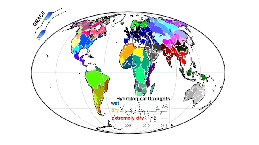
Recent international collaborations between Cardiff University’s School of Earth and Environmental Sciences and Water Research Institute and researchers from UK (University of Bristol), Australia (Curtin University and the Australian National University), and Germany (University of Bonn and University of Frankfurt), have identified that the integration of time-variable satellite gravity data into hydrological models improves them. The addition of this data enables the system to simulate surface and sub-surface compartments of the terrestrial water storage to a much more accurate level.
The Gravity Recovery And Climate Experiment (GRACE) satellite mission, which ran between 2002 and 2017, provided almost monthly global gravity data. GRACE data can be used to calculate changes in the Terrestrial Water Storage (TWS; a vertical summation of all available water storage compartments including canopy, surface water, snow, soil water, and groundwater). This satellite mission was unique because of GRACE’s sensitivity to groundwater changes, whereas signals of other remote sensing techniques barely penetrate through the layers of soil. A GRACE follow-on mission is planned for launch in 2018.

Scientists in the School of Earth and Environmental Sciences optimised the processing of the GRACE data before merging them with hydrological models. This integration is necessary for correcting model simulations, and also introduces processes such as anthropogenic water use that are reflected in the GRACE data but usually is not well presented by hydrological models.
The new model was tested on the (semi-)arid region of the Murray Darling River Basin in Australia and the feasibility of restoring the declining groundwater supply caused by the so-called ‘Millennium Drought’, which occurred in the region from 2001 until 2009. In comparison with other models, the new hydrological model which included the GRACE satellite data improved the simulation of groundwater and was able to identify long-term trends, which can be used in policy making across the region.
